
That moment when you wonder: “Will I fit?”
You know it well. The sat nav tells you to turn, the road narrows, and in three seconds every question hits you at once: how wide will it be further on? Is there a bridge? Does it open up at the end, or get worse? And the one that scares you most of all — if I have to turn back, where do I turn round?
Then there’s the even worse version: you realise you’ve ended up in a historic town centre, with cars behind you who don’t get it, and no room at all for mistakes.
It isn’t the sat nav’s fault. It just knows nothing about you. To it you’re a dot that has to get from A to B as fast as possible, and the village lane is the shortest way. Nobody told it you’re seven metres long, three metres tall and weigh three and a half tonnes.
Rino knows what you’re driving
You tell it once what your vehicle is like — height, width, length, weight — and from then on every route is worked out on those dimensions. It isn’t a filter bolted on afterwards: it’s how the route is built in the first place.
And before you set off, it tells you what lies ahead: how many kilometres run on minor roads, whether there are driving bans, whether there are stretches to take at walking pace. If there’s something it doesn’t like, it says so, instead of letting you find the surprise on a bend.
Then, as you drive, it warns you about roadworks, single-lane traffic lights and closed roads. Roadworks with temporary lights are a nuisance in a car; for you they’re something else, and it’s worth knowing half an hour earlier rather than when you’re already sitting at the red light.
These are indications based on map data, not guarantees. No app can promise you’ll fit. It’s there so you arrive better informed, not to decide for you.
And once you’ve arrived,
the other half begins
Because the trip doesn’t end when you stop. Rino keeps being useful after you’ve switched off the engine — which is, after all, half the time you spend in a motorhome.
Take a look before you go. From any point on the map you open street-level view and get a real idea: whether there’s a barrier at the entrance, how wide the gap is, whether the ground slopes. Two seconds of photos are worth half an hour of botched manoeuvres.
Find somewhere to empty the tanks. Fresh water and waste disposal points are all there, mapped by people who travel like you — a category ordinary sat navs simply don’t have.
Stopovers, campsites and car parks — the car parks only if they’re open-air and accessible: an underground garage is no use to anyone three metres tall.
And when something breaks, garages and tyre shops with their phone number: you call them from there and ask first whether they’ll take on a vehicle like yours. Because finding out after you’ve got there is the worst part of the day.
What it does
Made for a vehicle that isn’t a car: dimensions, overnight stops and the unexpected matter more. And for the whole trip, not just the road.
Built around your motorhome
Routes worked out on your vehicle’s dimensions — height, weight, length — with warnings about low bridges and restrictions.
Five ways to travel
By motorhome, by car, on foot, by bike or by public transport. The motorhome mode knows your dimensions; the other four are for when the van stays parked.
Stopovers and services
Motorhome stopovers, campsites, waste disposal points and car parks — only open-air, accessible ones — plus fuel stations with prices, garages and tyre shops.
Navigation, with the voice you choose
Clear directions and up-to-date speed limits. The voice has three settings: full, essential — just “exit 2”, when you need it — or mute.
What the trip will cost you
Tolls and fuel estimated on your real consumption, before you set off. So “motorway or A-road?” becomes a question with a number next to it.
The unexpected, in real time
Roadworks, closures and accidents flagged along the route — and the restrictions that apply to a large vehicle, not a car.
Offline maps
You download the areas you need, and the strip along your route preloads by itself: where there’s no signal, the map is still there.
Camper on the road
See who’s on your road or near your destination, and message them. You’re invisible until you decide otherwise; as soon as you stop, your position blurs and then disappears — and nobody sees where you’re heading.
Your notebook of places
Save a place, give it a rating, a note and photos — “barrier at 2.80, swing wide” — and it stays yours, on your phone.
Available in Italian, English, German, French, Dutch, Spanish and Portuguese.
What’s inside, in numbers
Not estimates: these are counts of what the app has on board today.
Counted on 17 September 2026. Fuel stations from the Italian Ministry’s price list, Italy only. Live traffic and offline maps for the whole of Europe, from Sicily to the North Cape.
And on the dashboard screen
CampeRino works with Android Auto. Plug in your phone and the sat nav moves to the dashboard screen: map, manoeuvre sign, distance and arrival time, without touching the phone.
In a motorhome that’s no luxury. The windscreen is tall and far away, a phone stuck on a suction mount is always in the wrong place, and looking at it means taking your eyes off a road you’re driving with seven metres behind you. On a fixed screen, at the right height, the next manoeuvre takes a glance.
It’s the same map, with your dimensions already in it: the route on the dashboard is the one worked out for your vehicle, not a generic one redone by the car.
It tells you if there’s a queue further along the route, and how long it is. Not how many minutes you’ll lose, because nobody really knows that number: knowing where the queue starts is enough to decide whether to stop for lunch or press on.
You choose the destination on the phone, which has the keyboard and the search. The dashboard screen keeps what you need while you drive, and nothing more: that’s how it should be.
You need a vehicle or head unit compatible with Android Auto. It isn’t available on iPhone yet.
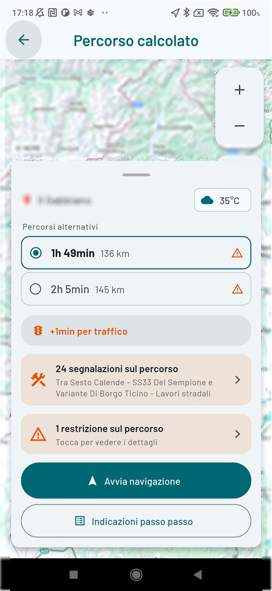
The route, worked out for your motorhome
Enter height, weight and length just once: CampeRino keeps them in mind for every route and avoids low bridges, narrow roads and restrictions on heavy vehicles.
Before you set off, a preview shows whether the route suits your vehicle. It’s a useful guide for planning, not a guarantee: careful driving is still down to you.
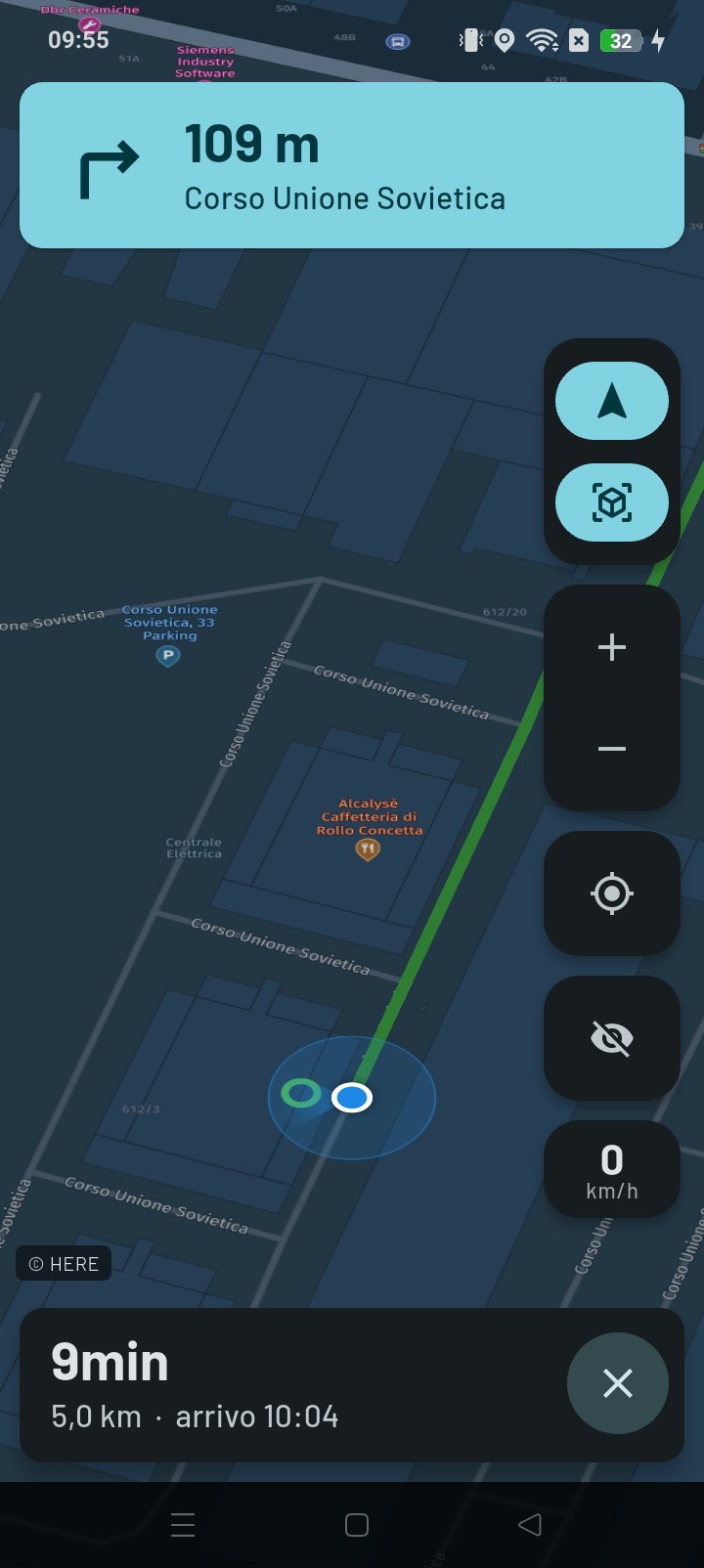
On the road, with clear directions
While navigating, the map follows the road in real time, pointing the way you’re driving, with up-to-date speed limits and warnings about roadworks, closures and accidents along the route.
You can tilt the view, so you see more of the road ahead and less of the road you’ve already covered.
Downloaded maps stay available even without signal, for the areas where coverage drops out.
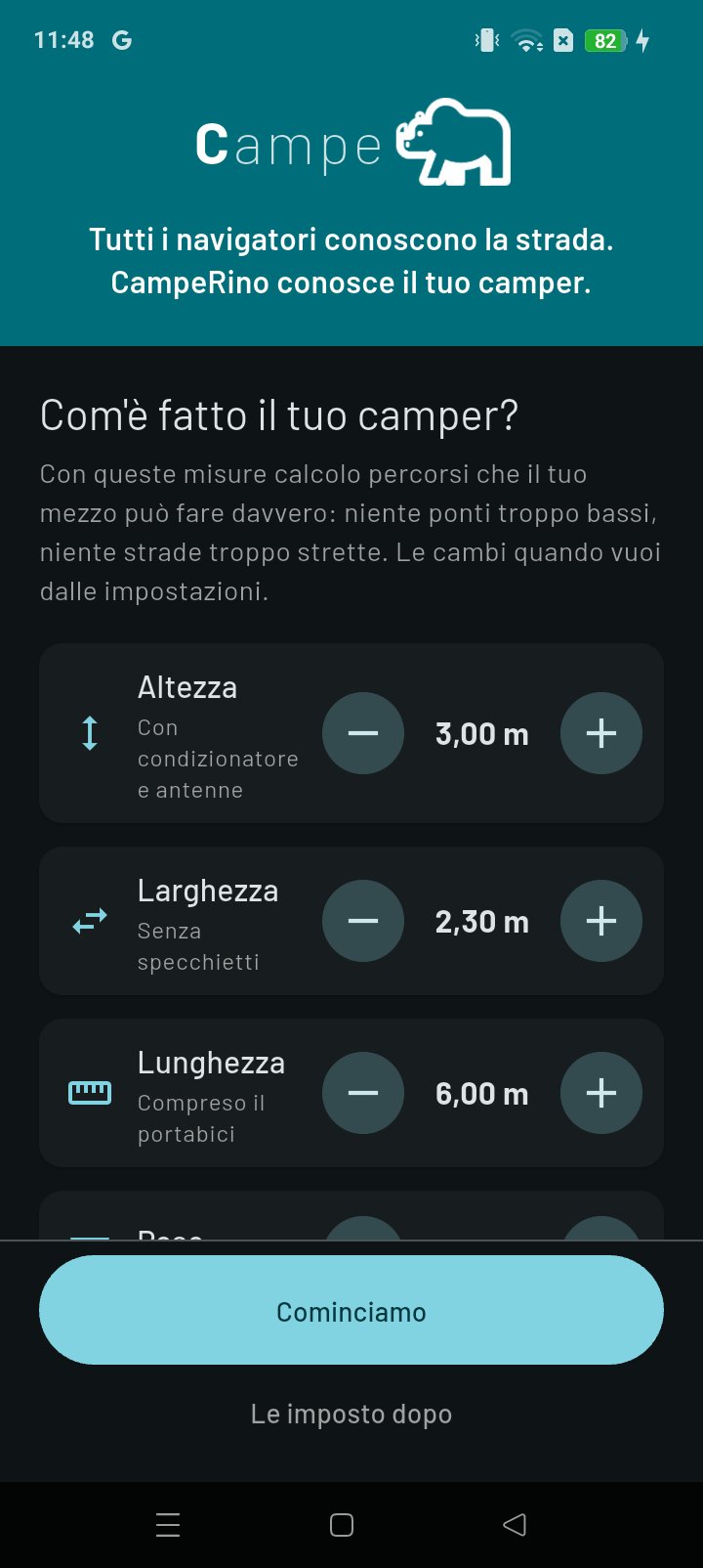
Tell it what your vehicle is like, just once
Height including the air conditioner, width without mirrors, length including the bike rack, weight. Then the fuel and the consumption — yours, not an average: if you don’t know it, you correct it after the first fill-up — because that’s where the cost of every route comes from.
If you tow a trailer or a caravan, say so: some roads and ferries don’t allow towing, and the route takes it into account. The axles, if you know them; and if you don’t, leave it on “Not sure”, because a made-up figure here is worse than none. From then on it all goes into every calculation, and you never have to think about it again.
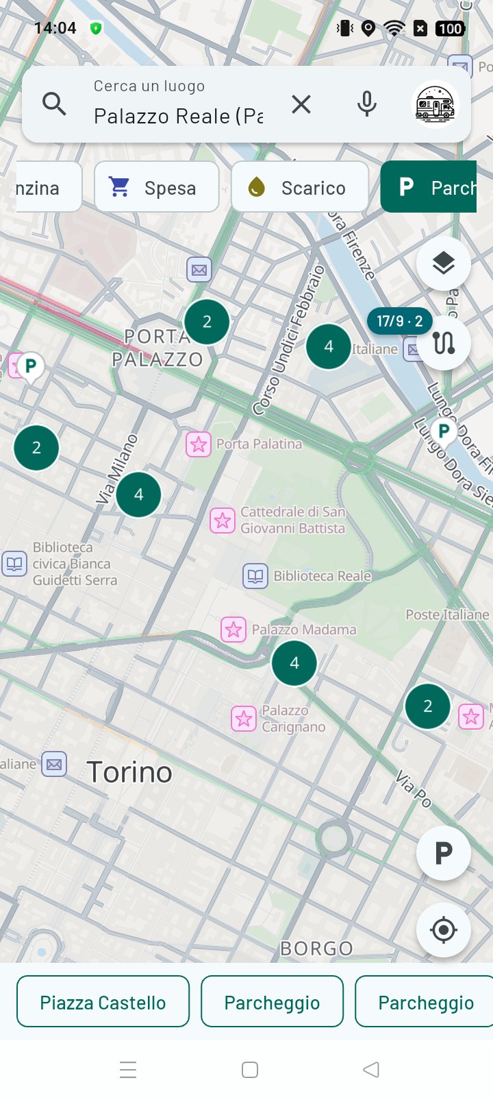
Only what you need, on the map
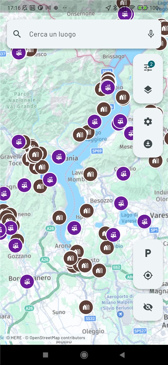
Stopovers, campsites, waste disposal, fuel with prices, car parks, food shops along the way. And garages and tyre shops too, for when you need someone who can actually take on a vehicle like yours.
Switch on only the categories you care about: the map stays readable, which is the whole point.
There are a lot of car parks, and from a distance they group themselves together. Close up, you decide how many to see: the 10, 20 or 50 nearest to where you’re looking, with a long press on the filter.
Stopovers, waste disposal points and car parks in fourteen countries, mapped by motorhomers themselves. Fuel prices come from the Italian Ministry, are updated daily, and apply in Italy only.
The whole trip, not just the road
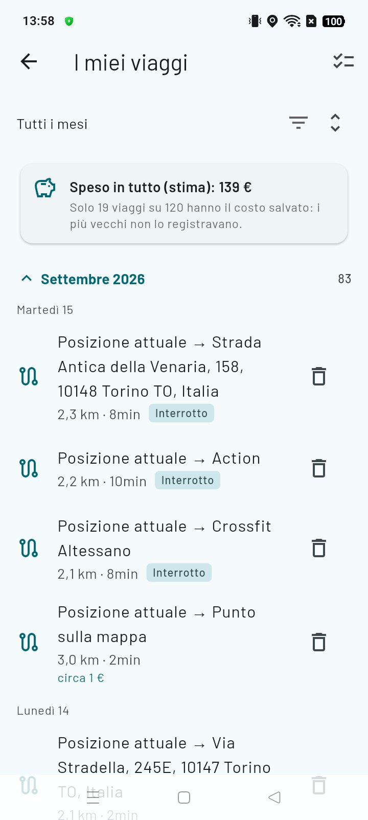
Plan your stops with dates — Briançon on the 19th, Lyon on the 21st — and for each one you see the road it’ll take you on before you leave. When the day comes, tap “Let’s go” and navigation picks up from wherever you are.
Every trip you make stays in your history: kilometres, times, and an estimate of what it cost in fuel and tolls. Not to do the sums at the end of the year, but to know what to expect next time.
The history records the track your phone actually travelled, and it stays on the phone. Costs are an estimate based on your vehicle’s consumption and the tolls stated by the map.
Who else is out there, right now
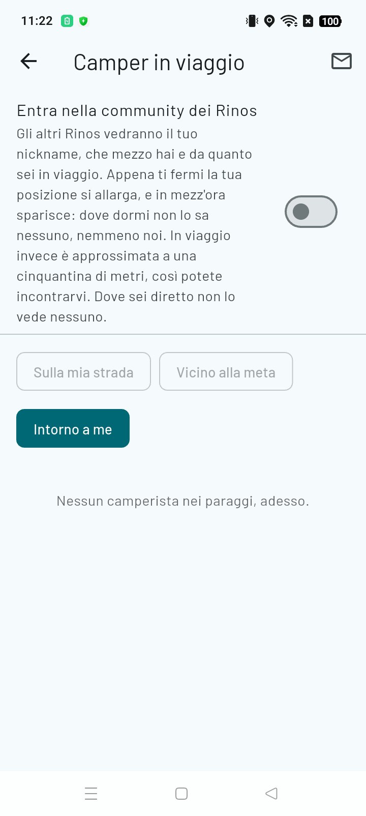
On your road, near where you’re heading, or simply around you. If someone’s there you’ll see them and can message them: to ask what that stopover is like before driving thirty kilometres to it, for a hand when you need one, or to travel a stretch together.
You’re invisible until you decide otherwise. And even when you’re visible, others see your nickname, your vehicle and roughly where you are: within fifty metres or so while you’re driving, so you can actually meet up. As soon as you stop, your position blurs to a kilometre, and within half an hour you vanish completely: nobody should know where you spend the night — not even us. And never where you’re heading.
And when there’s nobody around, it tells you so, instead of showing you an empty map and leaving you to think it’s broken.
The promise that matters
It won’t send you where you can’t get through. It’s the first thing it does and the only rule we’ve set ourselves: the route is built on your vehicle’s dimensions — height, width, length, weight — and it won’t let you discover an underpass is too low by driving up to it.
Anyone who drives a motorhome knows what we mean. It’s the lane that narrows after the bend with nowhere to turn. It’s the bridge with the sign you read from twenty metres away. It’s reversing with a queue behind you. A car sat nav doesn’t get it wrong by chance: it gets it wrong because, to it, you’re a car.
After that comes everything else, and it really is there. The voice, which you can set to essential so it says only the word you need. Five ways to travel. Stopovers, service points, car parks you’ll fit in. What the trip costs before you set off. Maps that stay on your phone where there’s no signal. Other motorhomers on your road. The dashboard screen.
But if we had to keep just one, it would always be the first: it takes you where you want to go, calmly, in your own vehicle — knowing how tall it is, how wide it is, and where it won’t fit.
CampeRino. Which, after your first trip together, becomes just Rino.
What it costs
For the first week everything is unlocked, no card and no commitment. After that, navigation built around your motorhome is the part you pay for — the rest of the app stays yours.
7 days
Everything on, from the first launch
Every feature, motorhome mode included. Seven days is a short holiday: time enough to try it on real roads, which is the only way to know whether you need it.
- No credit card
- No account
- Nothing to cancel
Rino Pro
The motorhome mode, and your trips on record.
from €2.50 a month, paid yearly
- Monthly€3.99
- 3 months€9.99 €3.33 a month
- 6 months€17.99 €3.00 a month
- Yearly −37%€29.99 €2.50 a month
- Motorhome navigation on your vehicle’s dimensions
- Toll costs before you set off
- Trip history, with kilometres and fuel use
- No ads
Rino Max
Everything in Pro, plus eyes on the road.
from €3.33 a month, paid yearly
- Monthly€5.99
- 3 months€14.99 €5.00 a month
- 6 months€26.99 €4.50 a month
- Yearly −44%€39.99 €3.33 a month
- Everything in Rino Pro
- Live traffic, with the route redoing itself when there’s a queue ahead
- Street View to see what a place looks like before you get there — the entrance to a stopover, the width of a gate
Four durations for each plan: the longer it is, the less it costs per month. Prices in euros, VAT included — the store shows you the exact price in your currency when you buy. You can switch plans whenever you like, and cancel from your account: you stay subscribed until the end of the period you’ve paid for, then go back to the free version without losing anything you’ve saved.
And if you don’t subscribe?
The app is still yours, and it doesn’t turn into a screen asking for money. Only one thing stops — the route worked out on your motorhome’s dimensions. Everything else keeps working, for good, with no expiry date.
- Four ways to travelBy car, on foot, by bike and by public transport — the ones you need most when the motorhome is parked.
- Stopovers and servicesService points, campsites, car parks, fuel stations with prices, garages and tyre shops.
- Your placesFavourites, a notebook with your own photos and notes, and other motorhomers’ ratings.
- Offline mapsThe areas you download stay on your phone, even where there’s no signal.
It’s a choice, not an oversight. An app that switches off when you stop paying gets uninstalled, and the places you’ve put in it go with it. This one stays useful even in the months the motorhome is laid up — and the day you set off again, navigation built around your vehicle is one tap away.
Frequently asked questions
What people ask before installing it.
How is CampeRino different from an ordinary sat nav?
An ordinary sat nav treats you like a car: to it you’re a dot that has to get from A to B as fast as possible. CampeRino knows how tall, wide, long and heavy you are, and works out the route on those dimensions — avoiding low bridges, roads that are too narrow and driving bans. It isn’t a filter applied afterwards: it’s how the route is built in the first place.
Is CampeRino free?
Partly, and for good. For the first week everything is unlocked, motorhome mode included, with no card and nothing to cancel. After that, navigation on your motorhome’s dimensions moves to Rino Pro or Rino Max, while the rest of the app stays free: you can navigate by car, on foot and by bike, find stopovers and fuel stations, save favourites and download offline maps. Both plans are explained above.
Does it work without an internet connection?
Yes, for the areas you downloaded before setting off: choose an area on the map, the app downloads its tiles and from then on they stay available even where your phone has no signal — which in the mountains and in valleys is the norm. Maps you’ve already looked at stay in memory anyway.
How does it know whether my motorhome will fit?
It reads the information that matters for a large vehicle from the road data: underpass heights, weight limits, width, driving bans. Before you set off it shows you what lies ahead — how many kilometres run on minor roads, whether there are stretches to take at walking pace. These are indications based on map data, not guarantees: no app can promise you’ll fit.
Where do I find stopovers, campsites and waste disposal points?
They’re categories you switch on on the map, along with car parks, fuel stations, garages and tyre shops. Stopovers, campsites and fresh water and waste disposal points are mapped by motorhomers themselves: it’s a category ordinary sat navs simply don’t have.
Is there a limit to how much I can use it?
Not in normal use, and you won’t hit it while travelling. Maps, routes and searches do come from services that are paid for per request, though, so each copy of the app has a cap on requests, and there’s an overall one for everyone: they’re there so that out-of-scale use doesn’t leave everyone else without service. If you ever reach it, the app tells you clearly instead of pretending something’s broken, and the count resets by itself shortly afterwards.
Which countries does it work in?
Maps, address search and route calculation work everywhere, not just in Italy. Fuel prices are the exception: they come from the public price list of the Italian Ministry of Enterprises and cover Italian fuel stations only.
Does it have voice guidance?
Yes, with three settings instead of two. Full announces manoeuvres in full. Essential says only the word you need — “exit 2” — and only when it’s time to look at the screen: it exists because a full voice ends up being switched off in the long run, and switching it off means losing the one thing you actually needed. Mute doesn’t speak at all, and it’s the default: a voice nobody asked for shouldn’t start talking after an update.
Which languages is it available in?
Seven: Italian, English, German, French, Dutch, Spanish and Portuguese. If your phone is set to a language we don’t have, the app switches to English. You can see distances in kilometres or miles, as you prefer, so crossing a border doesn’t mean converting in your head.
Can other motorhomers see me?
Only if you switch it on: you join the Rinos community with a switch that starts off. And even when it’s on, people see the nickname you choose, the type and length of your vehicle, and roughly where you are: within fifty metres or so while you’re driving — you’re on a public road, and it means you can actually meet up — while as soon as you stop your position blurs to a kilometre, and within half an hour you vanish completely. Nobody knows where you spend the night, not even us. Nobody sees where you’re heading. You can block anyone who messages you.
Is it only for motorhomes?
No: there are five ways to travel — motorhome, car, on foot, by bike and by public transport. The motorhome mode is the one that knows your dimensions and avoids places you can’t get through; the other four are for the half day when the van stays parked and you go off to explore the town.
Does CampeRino collect my data?
There’s no account, no sign-up, no advertising, and we don’t sell anything to anyone. Your preferences, your vehicle’s dimensions and your saved places, with their notes and photos, stay on your phone. We do have a server of our own, though — it holds the map key and keeps count of usage — and route and map requests go through it. Some features, off by default, send it a little more if you switch them on: the trip log and the Rinos community. It’s all explained, feature by feature, in the privacy policy.
Where to get it

Want to try the preview version? Join the test on Google Play
You’ll need an invitation: email us at info@camperino.app with the Google account email on your phone.